
Trace Monroe Township Streets by Address
The current address trail begins with a tax parcel, then moves through geography and recorded instruments. The county assessment search can identify an owner of record, the property location, block, lot, qualifier, class, and assessment details. GIS supplies the map position. The Clerk index then connects named parties and legal descriptions to a recorded deed. The state voter tool has a narrower role: it is an exact-name registration-status check, not a street roster. Historic directories can offer a household lead, but a complete local reverse-directory run was not verified.
- Open the county tax-records gateway, choose Monroe Township, and try the situs address. Save the block, lot, qualifier, owner, and tax year rather than relying on the street name alone.
- Find the same parcel in the Gloucester County ArcGIS hub. Click its polygon and compare roads, parcel boundaries, aerial imagery, and the municipal edge.
- Use the owner name and deed reference at the Gloucester land-record index. Read the legal description and the seller as well as the buyer.
- If a registration question remains, use the exact name in the state Voter Search. A non-match is not proof that someone is absent or unregistered.
- For an older household lead, ask the library or historical repositories for a titled reverse or criss-cross volume. Confirm its year and coverage before treating it as address evidence.
That order avoids a common error: turning one clue into a claim about every person on a Monroe Township street. The parcel record answers a tax and ownership question. The map confirms which land is meant. A deed records an instrument. Each source needs its own date and limit.
Search Monroe Township Street Parcels
The county links its assessment records through an external interface. Search it in more than one way: owner name, property location, and block and lot. Select Monroe Township first, because New Jersey has another Monroe Township in Middlesex County. The card may provide physical characteristics or a deed reference, but the county does not state a historical online cutoff, result cap, or export rule. For a street directory trail, transcribe the returned fields and the date viewed.
| Assessment search field | Use for a Monroe Township street search |
|---|---|
| Municipality | Select Monroe Township in Gloucester County before running a name or address query. |
| Owner name | Try surname or company name; partial-match behavior should be checked in the live form. |
| Property location | Enter the situs address and try street-spelling or directional variants. |
| Block and lot | Use the tax identifiers when an address is old, rural, split, or ambiguous. |
| Qualifier and class | A qualifier can separate records within a shared footprint; class is a tax category, not a resident count. |
The linked assessment search is useful for current tax data. Correcting an error or finding material not shown online goes to the county or municipal assessor, not to the map viewer. Do not convert a tax description into a claim that a named owner is physically present on the property today.
Read Monroe Township Street Addresses Carefully
One parcel can carry several addresses. The situs, or property address, is where the land sits and is how GIS, emergency addressing, and permits generally identify the site. The owner mailing address is where tax correspondence goes. It may be another residence, a post-office box, a business address, or an out-of-county address. The legal description is the block, lot, qualifier, subdivision, tract, or metes-and-bounds language that holds up when the street address changes.
Keep those labels separate in any street-by-street notes. An owner mailing address outside Williamstown is not evidence of a second person at the Monroe Township property. A homestead or owner-occupancy deduction can be a useful tax clue, but it does not prove a person was at an address on a particular day. This distinction is especially important where Williamstown is the postal identity while the legal municipality is Monroe Township.
- Parcel
- A tax-mapped piece of land, commonly identified in New Jersey by block, lot, and sometimes qualifier.
- Situs address
- The physical location of the parcel, not necessarily the place where its owner receives mail.
- Plat or subdivision map
- A filed map that shows lots, roads, and parcel relationships; it can bridge a later lot split.
- Criss-cross directory
- A directory arranged by address rather than alphabetically. No complete Monroe Township run was verified, so ask for a specific title and year.
Note: A mailing address can help locate correspondence, but it cannot be relabeled as a situs address or treated as current presence evidence.
Map Monroe Township Streets in GIS
Use the county GIS as a geographic check before treating similar street names as the same place. Its address or place search, parcel layer, and identify tool can lead to a parcel polygon or an assessment link. Roads, municipal boundaries, aerial imagery, zoning, land use, flood, wetlands, hydrology, and district layers add context. Layer dates vary, so a map can lag a recorded deed or a local addressing change.
The county's GIS gateway points to the ArcGIS viewer and identifies GIS Support through County Planning. Move along a street by clicking parcels instead of assuming a text search covers every frontage. A road can cross postal communities, ZIP codes, or a municipal boundary. The polygon establishes land geography; the assessment card supplies tax data; the Clerk index supplies the recorded ownership trail.
Note: A map layer is a dated geographic reference, so compare it with the deed recording date before drawing conclusions about a Monroe Township street.
Compare Monroe Township Street Records
Address-keyed sources answer different questions. Start with the record that actually holds the question, then use the next source to test it. The table below describes the access path, not a promise of a current occupant list. For sources without an online index, the counter, a written request, and archival repositories are part of the route.
| Address record | Custodian | Useful field or fact | How to reach it |
|---|---|---|---|
| Assessment parcel card | County assessment and municipal assessor | Owner, mailing and situs addresses, block/lot, class, assessment, sale or deed reference | County-linked search; assessor or municipal correction route |
| GIS parcel | County Planning/GIS | Parcel geometry, roads, adjoining lots, aerial and district layers | Public ArcGIS identify tools |
| Land-record index | Gloucester County Clerk | Named parties, instrument, recording date, book/page, legal description | Online series index, Record Room, older books and microfilm |
| Voter registry | State and county election offices | Permitted registration fields for a registered voter | Exact-name Voter Search or a lawful election-district list request |
| Zoning and construction files | Monroe Township offices | Work-site, applicant or owner, block/lot, work and approval details | Office records, agendas or resolutions, and OPRA where appropriate |
| Historic maps and directories | Libraries and historical repositories | Older building, street, business, or household context | Shelf, microfilm, digital-map, or archive inquiry |
A street directory record gains value when the parcel ID or legal description ties it to the other records. A street string alone is weak evidence for rural routes, subdivisions, roads with changing community labels, and parcels without a stable number.
Follow a Monroe Township Street Deed Chain
The Clerk's online index is the bridge from a current parcel to a recorded deed, mortgage, lien, map, or prior owner. Its documented computer coverage starts with deeds in 1959 and mortgages in 1967. Other series start later: assignments in 1987, discharges and releases in 1992, construction liens in 1994, and several lien or lis pendens series in 1987, 2001, or 2002. Older county records remain elsewhere even though the online index is newer.
Use the current owner as grantee around the last sale date, then read the deed for the grantor, recording and execution dates, legal description, consideration if present, and prior reference. Search that seller as a grantee for the earlier acquisition. This carries a Monroe Township street trail one instrument at a time. If the deed image is unavailable, the County Clerk Record Room can be reached at 856-853-3230; older books and indexes may also be found through the Clerk, microfilm, the Gloucester County Historical Society, the New Jersey State Archives, and FamilySearch.
The Gloucester County land-record index is the starting screen for that recorded trail.
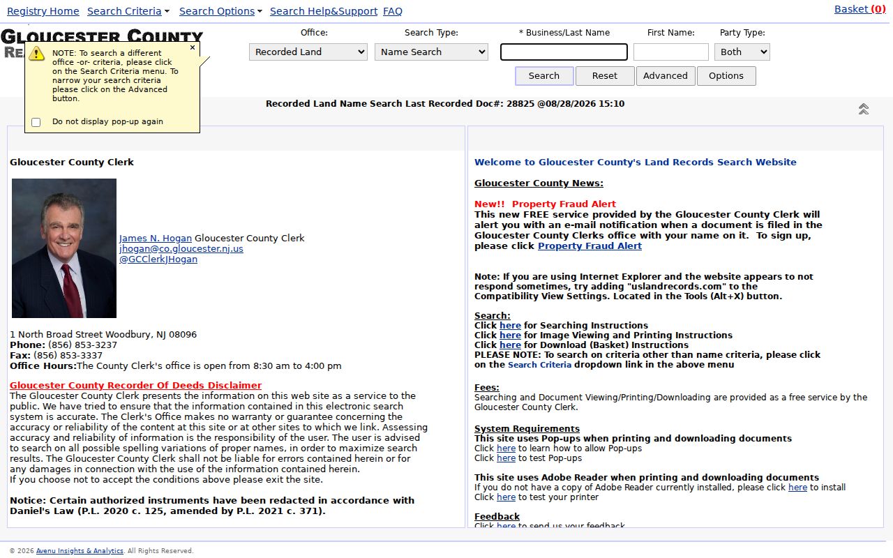
Capture the party names, instrument type, recording date, book/page or document number, and legal description before moving to the prior conveyance. The county says deed copies can be printed online without charge; its public notice also describes paper copies at about 5 cents per page and a $2 certification add-on.
Check 2016 Monroe Township Street Index Rule
Gloucester County warns that recorded instruments have not been cross-indexed by party type since October 1, 2016. That is a search limitation with real consequences for an address history. A grantor-only view can miss an instrument even though a name appears in its legal text. Search both parties, then try initials, married names, company names, punctuation variants, and the legal-description terms carried from the prior deed.
The result list should be treated as an index, not as the whole record. The instrument type, recording date, book/page, and document number show where to continue. Daniel's Law can also leave an index entry discoverable while restricting an image or physical book page. Ask the Record Room about the proper access path instead of assuming a missing image means the document never existed.
Note: A party-role filter is a narrowing tool, so read each instrument and compare its description before placing it in a Monroe Township chain.
Use Monroe Township Street Permit Records
Construction, zoning, and board material can date changes at a work site. The current Monroe zoning form asks for property address, block, lot, owner and mailing address, contractor information, proposed work, and approval details. It can support a build, addition, fence, sign, or other site-history question. It is not proof that an applicant lived at the parcel.
No public Monroe address-search permit database was located. Start with the construction or zoning office, then request the exact records needed. A focused Gloucester County OPRA form can help for county-held material, while township requests go to the proper municipal custodian. For a Monroe Township parcel, ask for permits, certificates, inspection records, and resolutions for a stated block, lot, and date range. The research documents that a complete application review may take up to 10 business days; it does not document an archive start date.
Note: A narrow request using a block, lot, and date range is more likely to reach the right address record than a request for everything about a street.
Handle Monroe Township Street Geography
Williamstown is the principal postal community, while Monroe Township is the legal municipality. A Monroe address may use Williamstown 08094, and portions of the township near the Clayton or Franklin Township side use Clayton 08312. Postal city names and ZIP boundaries do not decide the tax municipality. Select Monroe Township on county systems and verify the parcel and municipal-boundary layer before discarding a record with a different mailing city.
Older material can add Downer, Cross Keys, Cecil, New Brooklyn, Radix, Victory Lakes, a rural route, or a farm name. The research found no official Monroe street-renumbering or renaming event with a year. Do not invent one. When a historic address will not match today, use block, lot, legal description, subdivision map, historic map, road name, and adjacent owners. Williamstown Sanborn map sheets are identified for 1895, 1900, 1905, 1910, and 1923; they can show building and street context but are not title maps.
Find Older Monroe Township Street Clues
For household history, use a dated directory or census as a separate layer rather than treating an ownership chain as a list of everyone who lived there. The digitized 1913 Farm Journal directory has county-wide Williamstown and Monroe material. The identified 1860, 1890-91, and 1893-94 county-directory leads need shelf or catalog confirmation for local pages. The historical-directory collections themselves are described in the Monroe Township Directory Book.
The Monroe Township Historical Society reports a Plain Dealer microfilm collection and a reader/digitizer by appointment. GCHS holds newspapers, unrecorded deeds and surveys, family papers, church and cemetery material, and county records. The Free Public Library of Monroe Township can help search its catalog and shared catalog for exact titles or request material through interlibrary loan. Those are fallback paths, not proof that a private criss-cross directory exists for every Monroe Township street.
Note: An unverified reverse directory is only a lead until its title, year, address coverage, and original entry are checked at a repository.
Respect Monroe Township Street Directory Limits
A property record identifies the owner of record, not every person connected to an address. Public map and tax sources do not reveal private utility customers, delivery recipients, children, non-registered household members, or protected addresses. Driver address data is restricted under federal law. Election records also have their own limits: the individual tool is exact-name oriented, and protected voters can have addresses withheld.
New Jersey's Address Confidentiality Program and Daniel's Law protect certain addresses. A missing image or address can be a required redaction rather than an error. Use public records for family history, property curiosity, estate work, civic research, or to verify a document with its custodian. Do not use address information to threaten, repeatedly contact, intimidate, or surveil anyone.
Lawful use. Monroe Township street records support careful personal and historical research. New Jersey stalking and harassment laws prohibit using them to stalk, harass, intimidate, or harm another person.